Ridership in İzmir went up after the pandemic. The more useful question is what changed underneath that total.
In January 2021, with weekend curfews in force and schools teaching remotely, İzmirim Kart recorded 484,000 boardings a day. By February 2024 the figure was 1.74 million. Every mode grew, but not at the same pace, and the people boarding changed too.
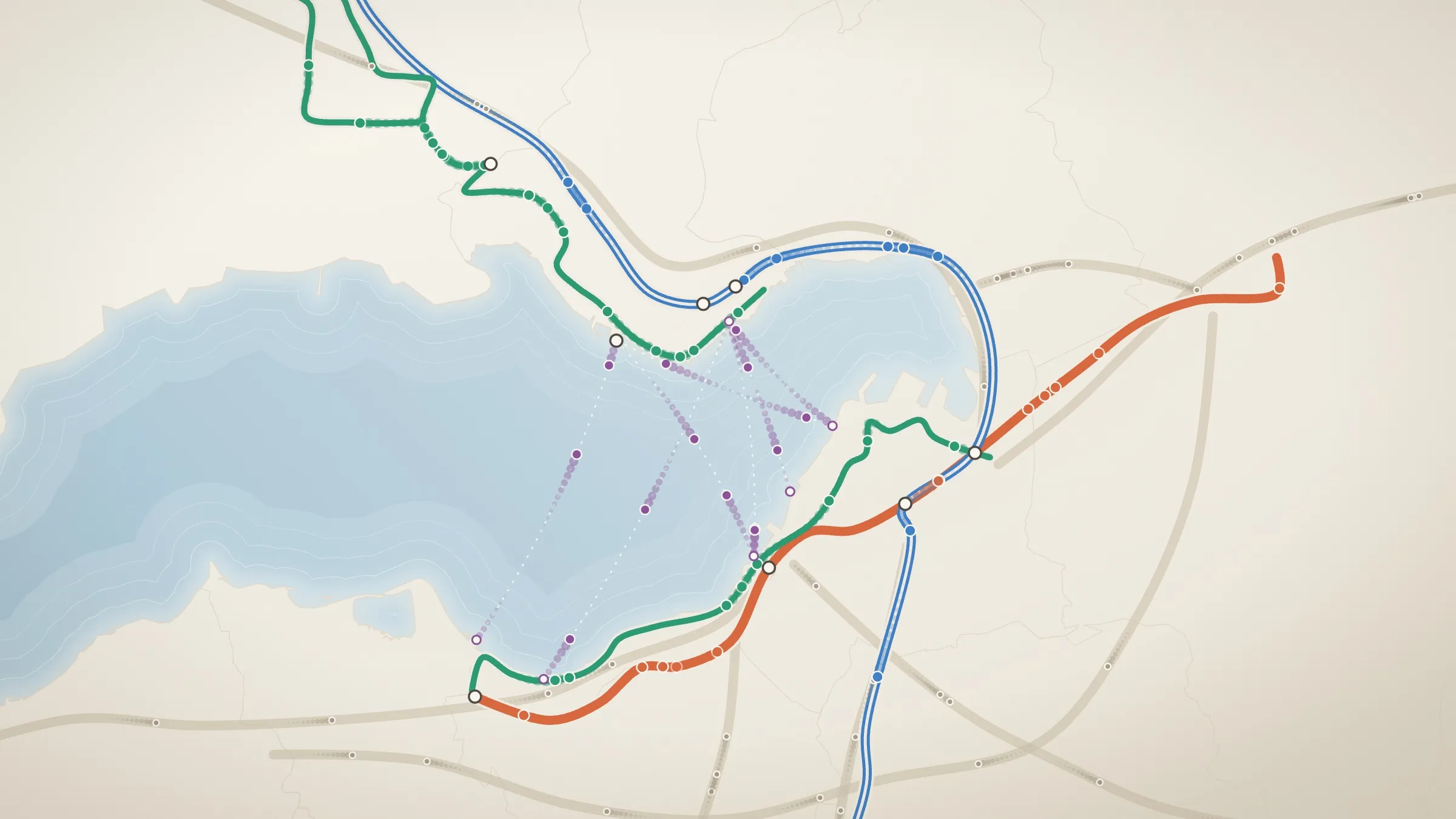
The map places the city’s own records on its own geography: the gulf, the district boundaries and the lines that cross them.
İzmir’s transit network, month by month
Each dot is a share of the day’s İzmirim Kart boardings, drawn on the line that carried them. Dots move faster where a mode has rebounded further from January 2021.
Daily boardings rose from 484k to about 1.8M. Trams rebounded most; buses carried six in ten boardings throughout.
- Bus
- Metro
- İZBAN
- Tram
- Ferry
- 1 dot ≈ 4,000 a day
February 2024
29 days1.74Mboardings a day
3.6× January 2021. Biggest rebound: Tram, 4.1×.
Çiğli tram opens
The Çiğli loop enters the data in mid-February, extending the Karşıyaka line north.
Select a mode to isolate it on the map.
- Full fare37%69%
- Student35%16%
- Free pass19%8%
- Aged 60+2%2%
- Teacher1%0%
- Other6%4%
Data table: boardings per day by month
| Month | Days | Bus | Metro | İZBAN | Tram | Ferry | Total | vs Jan 21 | Students |
|---|---|---|---|---|---|---|---|---|---|
| Jan 2021 | 31 | 283k | 85k | 79k | 24k | 13k | 484k | 1.0× | 16% |
| Feb 2021 | 28 | 345k | 106k | 98k | 31k | 16k | 597k | 1.2× | 19% |
| Mar 2021 | 31 | 492k | 142k | 129k | 48k | 24k | 835k | 1.7× | 24% |
| Apr 2021 | 30 | 374k | 109k | 102k | 33k | 16k | 635k | 1.3× | 21% |
| May 2021 | 31 | 260k | 73k | 74k | 22k | 11k | 441k | 0.9× | 19% |
| Jun 2021 | 30 | 492k | 149k | 141k | 51k | 28k | 862k | 1.8× | 22% |
| Jul 2021 | 31 | 570k | 158k | 160k | 58k | 33k | 982k | 2.0× | 20% |
| Aug 2021 | 31 | 630k | 179k | 171k | 64k | 35k | 1.08M | 2.2× | 21% |
| Sept 2021 | 30 | 782k | 219k | 202k | 82k | 39k | 1.34M | 2.8× | 27% |
| Oct 2021 | 31 | 815k | 234k | 207k | 83k | 40k | 1.38M | 2.9× | 31% |
| Nov 2021 | 30 | 821k | 241k | 207k | 81k | 36k | 1.39M | 2.9× | 32% |
| Dec 2021 | 31 | 848k | 240k | 206k | 81k | 32k | 1.41M | 2.9× | 33% |
| Jan 2022 | 31 | 793k | 223k | 192k | 74k | 32k | 1.31M | 2.7× | 31% |
| Feb 2022 | 28 | 856k | 233k | 209k | 84k | 36k | 1.42M | 2.9× | 30% |
| Mar 2022 | 31 | 988k | 271k | 229k | 92k | 38k | 1.62M | 3.3× | 32% |
| Apr 2022 | 30 | 970k | 269k | 237k | 93k | 41k | 1.61M | 3.3× | 30% |
| May 2022 | 31 | 956k | 252k | 235k | 91k | 45k | 1.58M | 3.3× | 30% |
| Jun 2022 | 30 | 979k | 267k | 238k | 94k | 44k | 1.63M | 3.4× | 29% |
| Jul 2022 | 31 | 818k | 195k | 200k | 71k | 37k | 1.33M | 2.7× | 24% |
| Aug 2022 | 31 | 880k | 224k | 220k | 83k | 42k | 1.45M | 3.0× | 25% |
| Sept 2022 | 30 | 1.03M | 268k | 248k | 100k | 45k | 1.71M | 3.5× | 31% |
| Oct 2022 | 31 | 1.12M | 299k | 261k | 101k | 46k | 1.83M | 3.8× | 37% |
| Nov 2022 | 30 | 1.09M | 292k | 252k | 95k | 42k | 1.78M | 3.7× | 36% |
| Dec 2022 | 31 | 1.09M | 290k | 250k | 98k | 40k | 1.77M | 3.7× | 36% |
| Jan 2023 | 31 | 1,000k | 263k | 233k | 90k | 40k | 1.63M | 3.4× | 34% |
| Feb 2023 | 28 | 918k | 234k | 217k | 85k | 37k | 1.50M | 3.1× | 30% |
| Mar 2023 | 31 | 1.03M | 252k | 233k | 92k | 38k | 1.65M | 3.4× | 33% |
| Apr 2023 | 30 | 954k | 234k | 223k | 86k | 37k | 1.54M | 3.2× | 32% |
| May 2023 | 31 | 1.03M | 257k | 241k | 96k | 42k | 1.68M | 3.5× | 33% |
| Jun 2023 | 30 | 929k | 227k | 221k | 83k | 38k | 1.51M | 3.1× | 31% |
| Jul 2023 | 31 | 871k | 202k | 214k | 71k | 35k | 1.40M | 2.9× | 29% |
| Aug 2023 | 31 | 894k | 207k | 218k | 76k | 39k | 1.44M | 3.0× | 29% |
| Sept 2023 | 30 | 1.04M | 249k | 235k | 99k | 44k | 1.69M | 3.5× | 33% |
| Oct 2023 | 31 | 1.13M | 294k | 254k | 100k | 46k | 1.83M | 3.8× | 38% |
| Nov 2023 | 30 | 1.06M | 275k | 240k | 90k | 36k | 1.70M | 3.5× | 38% |
| Dec 2023 | 31 | 1.07M | 283k | 243k | 95k | 39k | 1.73M | 3.6× | 38% |
| Jan 2024 | 31 | 976k | 252k | 224k | 85k | 37k | 1.58M | 3.3× | 35% |
| Feb 2024 | 29 | 1.08M | 274k | 243k | 100k | 44k | 1.74M | 3.6× | 35% |
| Mar 2024 | 22 | 1.09M | 281k | 245k | 101k | 44k | 1.76M | 3.6× | 37% |
How to read the map
- Dots are boardings. Each dot stands for about 4,000 boardings a day (6,000 on a phone), so a busier month draws a denser map.
- Speed is rebound. A mode’s dots move at its multiple of January 2021. A mode at 4× moves four times as fast as it did then.
- Each line has its own colour and style. İZBAN is hollow, Metro thick, trams thin, ferries dashed and bus corridors dotted, so the lines can be told apart without colour.
What stands out
- Trams rebounded most; Metro and İZBAN least. From January 2021 to February 2024, daily tram boardings grew 4.1×, buses 3.8×, ferries 3.4×, Metro 3.2× and İZBAN 3.1×. Rail carried more people than ever, but its share of boardings fell from 39% to 35%.
- Buses are the backbone. In every month, buses carried between 57% and 62% of boardings: six in ten of the 1.65 billion recorded over the period.
- The rebound came in steps. Boardings hit their lowest in the May 2021 lockdown (441,000 a day). They nearly doubled when restrictions eased in June and rose again when schools reopened in September. Summers dip. So did February 2023, when schools stayed closed until 20 February after the earthquakes.
- Students overtook full fare. Students made up 16% of boardings in January 2021. In October 2023, at 38%, they outnumbered full-fare riders for the first time, and they stayed ahead in every month since except the January–February semester break. Full fare fell from 69% to 35%, and free passes rose from 8% to 19%.
A note on the baseline
January 2021 is the first month in the data, and it was not a normal month. A multiple of 3.6× means 3.6 times a restricted winter month, not 3.6 times pre-pandemic ridership. A mode that slumped deeper in January 2021 also shows a bigger multiple later. The map measures rebound from that point, not recovery to 2019 levels.
Why a map?
İzmir’s network is shaped by its gulf. Ferries cross it. İZBAN and the Karşıyaka tram follow the northern shore, while Metro and the Konak tram follow the southern one. Buses reach the districts the rail lines do not. Placing the numbers on that geography shows where the growth happened, not just how much.
Data: İzmir Metropolitan Municipality Open Data Portal, İzmirim Kart daily boardings by operator and fare type. Station positions © OpenStreetMap contributors.